Mount Rainier was high on my priority list for this trip. After climbing to the summit in the summer of 2007 with my father, I really wanted to show Lea the mountain. Usually, when you are in Seattle you can see Mount Rainier off in the distance. It rises 14,410 feet above sea level and towers over the neighboring landscape. When we were in Seattle we could only see the base of the mountain as the top two-thirds was covered with clouds. On this day as we drove from Olympic to Rainier, we experienced the same complication: clouds!!
We didn’t have a campground and so when we pulled into the park just after noon we inquired about campsites at the front gate and the closest campground, Cougar Rock, had just filled within the hour and the only other campground was on the other side of the mountain, some 40 miles of mountain roads to get there. We decided to double back out of the park and try to find a site at Gifford Pinchot National Forest in a campground that was about ten minutes from the front gate. We pulled into the campground and found most of the sites were already occupied except for two spots; one was a single and one was a multiple car site. We quickly snatched up the single site, set-up out tent and then headed back into the park to drive up to Paradise.
As we drove up the construction-laden drive, we were not too optimistic about the views. The clouds were thick and there was never a view of the mountain, let alone the summit. We pulled into Paradise and saw about 100 feet in front of us, and that was about it. There wasn’t going to be any great views from hikes on this day. We talked with some of the rangers about the trail conditions and we decided that we would hike to Panorama Point tomorrow and for the remainder of the day we would just visit some of the lower falls and interesting spots.
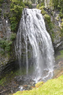
In addition to the construction occurring on the road, there was very limited parking. We were able to enjoy views of Narada Falls and wanted to check out Comet Falls (the highest in the Cascades), but the parking lots were beyond capacity and there wasn’t anywhere to consider parking.
We decided to just head back and we would go out to dinner in the town of Elbe because there was some cell reception for Lea and Verizon which allowed her to communicate about our next stop in the Portland area.
For dinner, we stopped at the Elbe Bar and Grille and I had one of the biggest sandwiches I have ever seen and we enjoyed our most reasonably priced meal of the trip. After dinner, we headed back to our campground and settled in. It was already chilly and the overnight temperatures were expected to dip into the low 40s.
The next morning we awoke to something that was not forecast: clouds. The day was supposed to be mostly sunny, and it was in spots, just not around Mount Rainier. We tried to remain optimistic, but as we drove up to Paradise, the views were worse than the previous day, and it was raining. We decided that we would abandon the Panoramic Point hike and head down to Comet Falls and hike that. As we descended from Paradise, the Comet Falls parking lot was full and there was nowhere to park – we were giving up on Mount Rainier. We decided to begin our trip to Portland, Oregon via Mount Saint Helens. An hour and a half drive brought us to the north side of Mount Saint Helens, the side where the eruption occurred in 1980.
We got stuck behind some classic cars on a rally through the area and we were forced to travel the 40 mph roads at only 15 mph, really slowing down our drive.
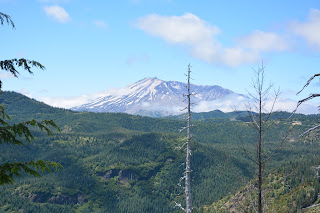
The views of Mt. St. Helens were great. There were some clouds covering parts of the mountain at times but the idea of the mountain was fully visible.
We drove out to Windy Ridge and then hiked up some stairs for a nice high view of the volcano and Sprit Lake. We could see Mt. Adams off in the distance and Mt. Hood was visible too at spots.


No comments:
Post a Comment