Sunday, July 31, 2016

Redwoods National Park and Coastal Highway

We awoke to chilly temperatures in Crater Lake and eventually said our goodbye’s to Alena.  We knew we had a longer drive (six hours) ahead of us so we intended to get going as early as we could.  Our site was all packed up and we were on the road by 9:15. 

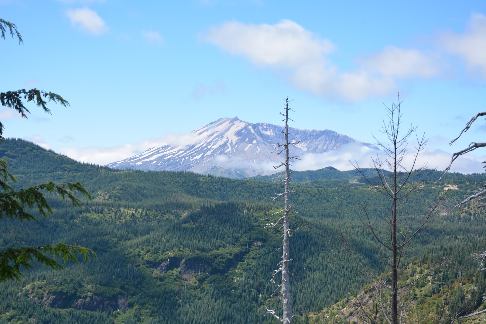
The drive down took us on a tour of the Volcanic Scenic Highway through Oregon before we eventually met up with the I-5 and headed just north to Grant’s Pass.  From here we eventually joined up with US 101 and headed down the coast to California after a quick stop at an agricultural checkpoint to avoid any potential pest coming into the state and destroying their crops.  Over the course of our trip, we have observed many different methods used to prevent the spread of invasive species.  All through Montana and Wyoming there were boat inspection stations and spraying stations to prevent aquatic invasive hitchhikers from traveling from one body of water to another.  There were multiple signs informing people of the spread of invasive and in the case of Crater Lake they banned snorkeling and scuba from the lake as a precaution.  These species are a major threat to the tourism industries (sportfishing) and agricultural industries, let alone the potential ecological disturbances that can arise. 

We reached the northern edge of Redwood National Park around 3:30 and stopped into a visitor station to learn the interesting things to do.  He suggested we backtrack up the road we came in on for a couple miles and take the scenic route to Crescent City where we would meet up with the 101.  We obliged and even took his advice to take a swim in the Smith River.  We pulled up to a swimming hole and jumped in.  Again there was a nice rock to jump off of into the water, so I did.  This water wasn’t as cold as Crater Lake but was a nice welcome to the heat of the day which had reached over 100 degrees during our drive. 

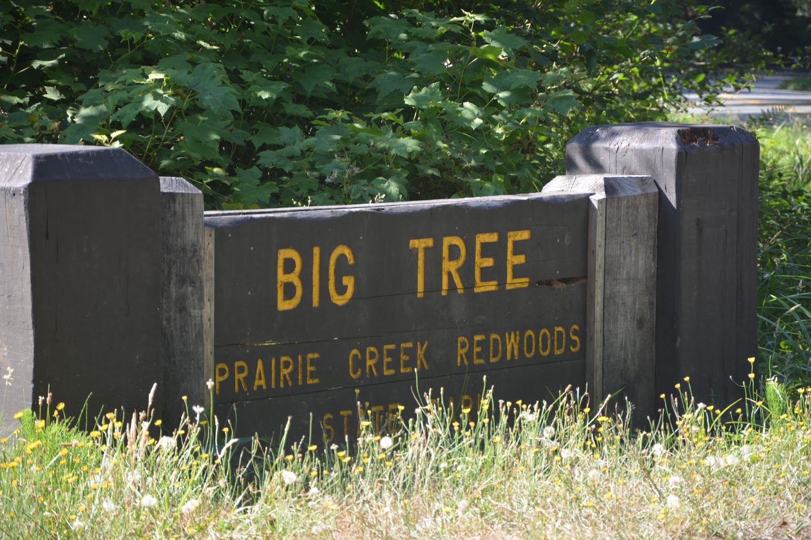
We continued down the Howland Hill road until we reached the Stout Grove.  This grove of old growth redwood trees was the “Old Faithful” of the park according to the ranger we talked to. A picture cannot do justice - the trees are at least 10 feet in diameter and over 100 feet tall. 


After enjoying the grove, we continued through the road to Crescent City, where we resupplied on some fresh groceries for dinner.  We then headed south to our campsite.  We settled into the campsite, set up our tent, whipped up some nice lentil and quinoa soup and quesadillas and then headed to bed.  Our next day would be another longer drive but it would take us along the coastal highway for a long stretch so it was planned to be very scenic. 

We woke up, packed up our site and planned a location for breakfast.  We planned to stop at the Klamath River overlook where it is possible to see seals and potentially whales from the overlooking cliffs.  We pulled in and we saw a wall of clouds.  The ocean, as far as we could see, was covered with clouds.  Our plan to drive this scenic route had hit a major roadblock in the first 20 minutes.


 We proceeded on because that was the only option.  We headed south to another scenic byway (the Newton Drury Scenic Parkway) through another old-growth redwood stand.  This winded us down and around eventually meeting up with the 101 again.  We then hopped back on the 101 and headed south through numerous small towns and eventually made a turn off to head to Fort Bragg and enjoy the coastal views. 


Our views for the entire drive consisted of the shoreline opaqued by fog coming off of the ocean.  We could at times see faint waves crashing on the shore, but the trend for the three hour stretch of the drive was the first 50 yards of the coast were covered in a thick fog, the remaining inland area was cloud-free.  With each mile, we kept thinking the fog was going to break, but as we pulled into Salt Point State Park for the evening, we have yet to see an unobstructed view of the Pacific Ocean.  Oh well.  

Crater Lake

Our drive to Crater Lake was nice and easy.  It was actually part of a conversation Lea and I had about longer drives.  We knocked out four and a half hour drive like it was just another day, whereas, in the course of normalcy, I would never consider a four and a half hour drive easy. 

The campgrounds in Crater Lake are by reservation only so we knew we didn’t have a reservation for the first night, but we did have a reservation for the second night we were planning on being there.  We did some preliminary research on the surrounding National Forest lands and we identified Diamond Lake as a potential site for our camp.  We drove straight there in attempts to secure a site.  Diamond Lake is a massive campsite with over 180 sites, so the odds of us getting one were high.  We pulled in and we were directed to the K and L loops.  We drove through both of these loops and there were only three sites available; none of them interested us.  As we were returning back to the front gatehouse, we noticed some vacant lots on another loop and as we talked with the ranger at the gate, she informed us that we could find an empty site in any of the loops, but most of them were reserved.  We took a quick drive through the other loops and found them to be less than 25% filled so we claimed two adjacent lots, one for us and one for Alena.  The first challenge was done! 

After securing our sites for the evening, Lea and I proceeded into Crater Lake to hopefully talk with a ranger about good hikes for the following day.  As with every park we visit this year, there is road construction and one-way roads which cause delays up to 20 minutes at a time.  We eventually made it to the ranger station at 5:05 and they close up at 5:00.  Oh well. 


We decided to look over the map on our own and identify some hikes which really interested us.  We planned on some shorter hikes, one to the top of Watchman’s Tower and one that went down to the lake.  Both of these hikes were short, only about a mile long each, but there were difficult due to the angle of the terrain.


Lea and I drove around the ridge for a short stretch before we decided to head back to the camp and set everything up and cook some dinner before Alena arrived.  As we set-up our camp we realized a major problem with the sites: mosquitoes.  They were persistent, large, and out for blood! No amount of bug spray or campfire smoke deterred them so we just donned long sleeves and pants and settled in for a potentially miserable evening. 

Alena eventually arrived at the site and we hung out for a while, sharing stories and enjoying the fire before we turned in for the evening.  We all agreed to the plan for the next day and looked forward to the different areas we were going to explore. 

We woke up, packed up camp, and were in Crater Lake by 10:00.  We headed straight for the Watchman’s Tower because the parking lot is small and it seemed to fill up fast.  The tower is an old fire watch station with views for hundreds of miles.  It was from these vantage points that forest fires could be detected or monitored and then nearby people could be alerted.  The views into the lake are remarkable and from any vantage point, it becomes clear how pure the water is.  The lake water is a rich shade of blue which we hadn’t seen on this trip.  We have seen cerulean blues in the prismatic springs of Yellowstone, incredible light blues in Glacier because of the pulverized rock, but this pristine deep rich blue was something else. 


After climbing around the Watchman’s Tower for a little while we headed over to the Cleetwood Trail where they launch sightseeing boat tours of Crater Lake.  These are the only watercraft allowed in the lake and they take 37 passengers out at a time.  In the area surrounding where the boats launched are areas which are perfect for swimming.  Each year Crater Lake receives over 500 inches of snow.  Crater Lake is also close to 2000 feet deep so… the water is cold!  Lea and I decided that there wasn’t much getting in the way of us swimming in Crater Lake and instead of slowly working our way in we decided to just jump off of the nearby cliff into the lake.  The jump was between 15 and 20 feet and plunged right into the chilly waters.  It was the only way to totally immerse yourself in the cooler water.  Lea and I jumped off a couple of times before heading over to Alena and relaxed in the warming sun for a couple of minutes before we headed back up the caldera rim and out.  The climb up was far more taxing than the way down and we would have enjoyed a swim post climb, but that was not the topography of the area. 


For the rest of the afternoon, we circled around the caldera rim, enjoying the varying views of the lake, the phantom ship, and the famous Wizard Island which is the new volcanic cone rising up from the collapsed caldera. 

We arrived back at the campsite and relaxed for a while.  Last night had a beautiful, cloud-free sky with amazing views of the stars so I planned on taking some star pictures.  In the evening I left the park and drove for a couple mile before I reached an open field where I choose to take the pictures of the stars.  I am looking forward to the deserts of Utah for more opportunities to take pictures of the stars. 


I drove back to the campsite and was asleep by 11:30.  We plan to drive down to Redwoods National Park tomorrow and enjoy the massive trees.  

Saturday, July 30, 2016

Portland and Surroundings

After getting a nice shower and comfortable bed to sleep on we awoke and headed into Portland.  Having never been to Portland I didn’t know what to expect.  There were a couple targets for the day (Powell Books, Saturday Market, Tilikum Crossing, and the International Rose Test Garden). We started with Powell Books. 

Powell Books is a large independent bookstore that takes up an entire city block and has three floors.  It was fun to peruse through the books and to see the different offerings in our favorite categories. 

After Powell books, we went to the very large Saturday Market where there are vendors of all types.  There were dozens of food and craft vendors.  There were street performers and a large crowd buying all sorts of different wares. 

We enjoyed the market for a while then we headed to get a bite to eat at the Old Town Brewery and Pizzeria.  We enjoyed a simple appetizer and some drinks then we had to head back to the car and drive down to the Tilikum Crossing.  This bridge does not have car traffic, but rather pedestrians, bikers, and the tram and is a new addition to Portland. Crossing bridges is one of Lea’s favorite things to do.  The structure is beautiful with pedestrian lanes and bike lanes on both sides and in the center are the tram lanes. 


We were getting tired after a long day walking around and we were ready to leave and we remembered we were told to visit the International Rose Test Garden.  We pulled into the city park complex and worked our way around to the Rose Garden and we were amazed at the number of roses, the beauty of the roses and of course the variations in the smells of the roses. 


After walking around the rose garden for a bit we headed back to Forest Grove and met up with Alena where we decided to treat her to some sushi at her favorite local sushi venue. 

The next day we awoke and our plan was to visit Cannon Beach, famous for the large rock formations which sit just off the beach.  This is the famous series of rocks which align with the key from One-Eyed Willy of the Goonies fame.  Alena’s friend told us to skip Canon beach in favor of Oliver West State Park which is just south and has very little tourist traffic and would still afford us the chance to see the beautiful multicolored sea stars.  We agreed and headed for the beach with intentions of arriving right at low tide.  We pulled in, hiked down to the beach and scoured the rocks in search of sea stars.  None!! Oliver West beach was absolutely beautiful as described and there were few people there, just a few surfers and as we left there were more and more families pulling in.  


Since we struck out on sea stars we headed back north to Canon Beach for another chance.  It was very difficult to find a parking spot, but eventually, we did and we hiked directly over to the rocks.


The largest rock is Haystack Rock and has a large colony of nesting seabirds on it.  Unlike Oliver West beach, this beach was crowded.  There were three-wheeled bikes rolling all around, hundreds of people, and clouds.  We were only 10 minutes north of our previous site and we had clear skies and now there wasn’t a break in the sky.  We started to look around on some of the rock outcroppings as the tide was coming in and again we struck out on finding sea stars.  Later on, did we learn that there has been a major die-off of the sea star from what they call the red tide, whihc is linked to a warmer ocean. 

On our walk back from the rock arrangement we stumbled onto a gentleman who was flying one of the most complex kites I have ever seen.  He controlled it so well and was able to buzz the sand, coming within a few feet from crashing each time. 


We headed back to Forest Grove and ordered some Thai food take out and relaxed for the evening.  Tomorrow we are heading for Crater Lake National Park and Alena is joining us!

Mount Rainier and Mount Saint Helens

 Mount Rainier was high on my priority list for this trip.  After climbing to the summit in the summer of 2007 with my father, I really wanted to show Lea the mountain.  Usually, when you are in Seattle you can see Mount Rainier off in the distance.  It rises 14,410 feet above sea level and towers over the neighboring landscape.  When we were in Seattle we could only see the base of the mountain as the top two-thirds was covered with clouds.  On this day as we drove from Olympic to Rainier, we experienced the same complication: clouds!! 


We didn’t have a campground and so when we pulled into the park just after noon we inquired about campsites at the front gate and the closest campground, Cougar Rock, had just filled within the hour and the only other campground was on the other side of the mountain, some 40 miles of mountain roads to get there.  We decided to double back out of the park and try to find a site at Gifford Pinchot National Forest in a campground that was about ten minutes from the front gate.  We pulled into the campground and found most of the sites were already occupied except for two spots; one was a single and one was a multiple car site.  We quickly snatched up the single site, set-up out tent and then headed back into the park to drive up to Paradise.

As we drove up the construction-laden drive, we were not too optimistic about the views.  The clouds were thick and there was never a view of the mountain, let alone the summit.  We pulled into Paradise and saw about 100 feet in front of us, and that was about it.  There wasn’t going to be any great views from hikes on this day.  We talked with some of the rangers about the trail conditions and we decided that we would hike to Panorama Point tomorrow and for the remainder of the day we would just visit some of the lower falls and interesting spots. 

In addition to the construction occurring on the road, there was very limited parking.  We were able to enjoy views of Narada Falls and wanted to check out Comet Falls (the highest in the Cascades), but the parking lots were beyond capacity and there wasn’t anywhere to consider parking. 


We decided to just head back and we would go out to dinner in the town of Elbe because there was some cell reception for Lea and Verizon which allowed her to communicate about our next stop in the Portland area. 

For dinner, we stopped at the Elbe Bar and Grille and I had one of the biggest sandwiches I have ever seen and we enjoyed our most reasonably priced meal of the trip.  After dinner, we headed back to our campground and settled in.  It was already chilly and the overnight temperatures were expected to dip into the low 40s. 

The next morning we awoke to something that was not forecast: clouds.  The day was supposed to be mostly sunny, and it was in spots, just not around Mount Rainier.  We tried to remain optimistic, but as we drove up to Paradise, the views were worse than the previous day, and it was raining.  We decided that we would abandon the Panoramic Point hike and head down to Comet Falls and hike that.  As we descended from Paradise, the Comet Falls parking lot was full and there was nowhere to park – we were giving up on Mount Rainier. We decided to begin our trip to Portland, Oregon via Mount Saint Helens.  An hour and a half drive brought us to the north side of Mount Saint Helens, the side where the eruption occurred in 1980. 


We got stuck behind some classic cars on a rally through the area and we were forced to travel the 40 mph roads at only 15 mph, really slowing down our drive.

The views of Mt. St. Helens were great.  There were some clouds covering parts of the mountain at times but the idea of the mountain was fully visible. 

We drove out to Windy Ridge and then hiked up some stairs for a nice high view of the volcano and Sprit Lake.  We could see Mt. Adams off in the distance and Mt. Hood was visible too at spots.   

After exploring Mt. St. Helens for a while we hopped back in the car and proceeded to head south to Forest Grove where Lea’s friend and college roommate Alena lived.  Alena graciously allowed us to stay with her for a couple days so we could explore Portland and the nearby attractions.